California Business and Professions Code § 8726 defines the practice of land surveying in California. A person practices land surveying if they, in any capacity, perform any of the following:
- Locates, relocates, establishes, reestablishes, or retraces the alignment or elevation for any of the fixed works embraced within the practice of civil engineering.
- Determine the configuration or contour of the earth’s surface or the position of fixed objects using mathematics or photogrammetry.
- Locates, relocates, establishes, reestablishes, or retraces any property line or boundary of any parcel of land, right-of-way, easement, or alignment of those lines or boundaries.
- By the use of the principles of land surveying determines the position for any monument or reference point that marks a property line, boundary, or corner, or sets, resets, or replaces any such monument or reference point.
- Conduct surveys for the subdivision or resubdivision of land.
- Perform geodetic or cadastral surveying (accounting for the Earth’s shape to determine horizontal/vertical positions or define public land boundaries).
- Prepare or modify electronic data used in land surveying activities. Render statements about the accuracy of maps or survey data.
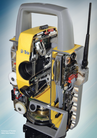
The foundation of modern land surveying, the “total station” is not a camera at all, although some do have imaging capabilities. Used for precise measurements, today’s cutting edge robotic total stations use laser technology to measure distances and angles with extreme precision—down to seconds of arc.
By combining measured distances and angles referenced to known control points, total stations allow surveyors to accurately determine the position of features relative to one another, forming the basis of reliable spatial data.
By combining measured distances and angles referenced to known control points, total stations allow surveyors to accurately determine the position of features relative to one another, forming the basis of reliable spatial data.
A significant portion of the surveying process occurs outside of what you see in the field. Survey work often begins in the office, where historical research and technical calculations are performed to establish a framework for field operations.
After field measurements are collected, the data returns to the office for analysis, verification, and final processing. This workflow assumes that field conditions will allow for uninterrupted work—an assumption that is not always met. Surveyors regularly contend with challenges such as disturbed or missing monuments, limited site access, environmental conditions, and a host of other unforeseen obstacles.
After field measurements are collected, the data returns to the office for analysis, verification, and final processing. This workflow assumes that field conditions will allow for uninterrupted work—an assumption that is not always met. Surveyors regularly contend with challenges such as disturbed or missing monuments, limited site access, environmental conditions, and a host of other unforeseen obstacles.
Short answer, no. All land surveying work must be performed by or under the responsible charge of a licensed land surveyor or civil engineer (CA BPC § 8729). A lot goes into performing a successful and accurate survey: researching historical records, checking existing boundary markers, and verifying measurements with adjoining properties are just some of the steps that must be taken to ensure your survey is accurate, legally defensible, and consistent with surrounding lots.
Successfully navigating these complexities requires technical skill, adaptability, and experience. Just like you wouldn’t want some junior mechanic taking apart your car’s engine, a licensed surveyor makes sure the job is done right the first time, and the results will stand up to any amount of scrutiny.
Successfully navigating these complexities requires technical skill, adaptability, and experience. Just like you wouldn’t want some junior mechanic taking apart your car’s engine, a licensed surveyor makes sure the job is done right the first time, and the results will stand up to any amount of scrutiny.
Surprisingly, it happens all the time! Many urban lots in old subdivisions lack clear monuments, and property lines can be ambiguous to say the least. Surveyors identify and resolve these discrepancies so your property boundaries are correctly and properly defined.
In case you haven’t found the answer for your question please feel free to contact us, we will be happy to help.